
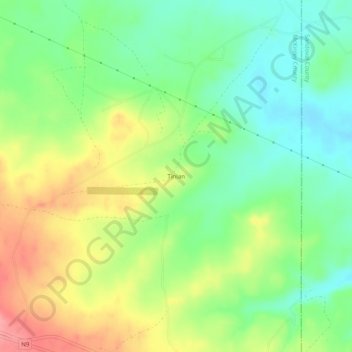
Tinian topographic map
Interactive map
Click on the map to display elevation.
About this map
Name: Tinian topographic map, elevation, terrain.
Average elevation: 6,608 ft
Minimum elevation: 6,480 ft
Maximum elevation: 6,788 ft
McKinley County trails, hiking, mountain biking, running and outdoor activities
Other topographic maps
Click on a map to view its topography, its elevation and its terrain.
Crownpoint
United States > New Mexico > McKinley County
Crownpoint is in central McKinley County along New Mexico State Road 371, which leads south 23 miles (37 km) to Thoreau and Interstate 40, and north 83 miles (134 km) to Farmington. The community sits at an elevation of 6,851 feet (2,088 m) on land that drains toward the Chaco River 30 miles (48 km) to the…
Average elevation: 6,886 ft
Gallup
United States > New Mexico > McKinley County
Gallup, like most of the interior Mountain West, has a cool semiarid climate (Köppen BSk). The summers are hot during the day, but the high altitude and low humidity mean that nights remain distinctly cool; as late as July 2, 1997, the temperature fell to 31 °F (−1 °C). Despite the large diurnal…
Average elevation: 6,781 ft