
Panama Canal topographic map
Interactive map
Click on the map to display elevation.
About this map
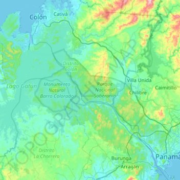
Name: Panama Canal topographic map, elevation, terrain.
Location: Panama Canal, Distrito Colón, Colón, 7338, Panama (8.90638 -79.92624 9.40041 -79.53357)
Average elevation: 302 ft
Minimum elevation: -3 ft
Maximum elevation: 2,277 ft
Other topographic maps
Click on a map to view its topography, its elevation and its terrain.
Fort Sherman
Panama > Colón > Distrito Colón > Cristóbal
Between 1966 and 1979, 1,160 sounding rockets with maximum flight altitudes of 99 kilometres were launched from Fort Sherman. Fort Sherman was used in the filming of the 2008 James Bond film Quantum of Solace.
Average elevation: 23 ft