
Gold Hill topographic map
Interactive map
Click on the map to display elevation.
About this map
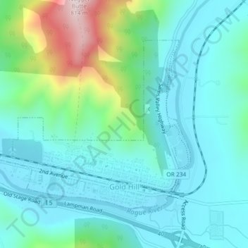
Name: Gold Hill topographic map, elevation, terrain.
Location: Gold Hill, Jackson County, Oregon, United States (42.42940 -123.07284 42.44771 -123.04083)
Average elevation: 1,365 ft
Minimum elevation: 1,033 ft
Maximum elevation: 2,595 ft
Jackson County trails, hiking, mountain biking, running and outdoor activities
Other topographic maps
Click on a map to view its topography, its elevation and its terrain.
Siskiyou Gap
United States > Oregon > Jackson County
"The original pass crosses the divide between the Rogue and Klamath Rivers at a slight topographic notch formed by the geological contact between the older Siskiyou Mountains to the west and the younger volcanic Cascade Range to the east." (Jeffrey M. LaLande, retired, forest archaeologist, Rogue…
Average elevation: 5,728 ft