
Bradford topographic map
Interactive map
Click on the map to display elevation.
About this map
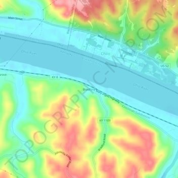
Name: Bradford topographic map, elevation, terrain.
Location: Bradford, Bracken County, Kentucky, 45112, United States (38.76507 -84.16549 38.80507 -84.12549)
Average elevation: 617 ft
Minimum elevation: 472 ft
Maximum elevation: 886 ft
Kentucky trails, hiking, mountain biking, running and outdoor activities