
Cold Spring topographic map
Interactive map
Click on the map to display elevation.
About this map
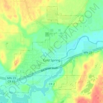
Name: Cold Spring topographic map, elevation, terrain.
Location: Cold Spring, Stearns County, Minnesota, 56320, United States (45.44041 -94.46056 45.47844 -94.39871)
Average elevation: 1,145 ft
Minimum elevation: 1,073 ft
Maximum elevation: 1,257 ft
Stearns County trails, hiking, mountain biking, running and outdoor activities
Other topographic maps
Click on a map to view its topography, its elevation and its terrain.
Pearl Lake
United States > Minnesota > Stearns County > Maine Prairie Township
Average elevation: 1,125 ft