
Boonville topographic map
Interactive map
Click on the map to display elevation.
Boonville
Boonville (formerly The Corners and Kendall's City) is a census-designated place (CDP) in Mendocino County, California, United States. It is located 12.5 miles (20 km) southwest of Ukiah, at an elevation of 381 feet (116 m). The population was 1,018 at the 2020 census.
About this map
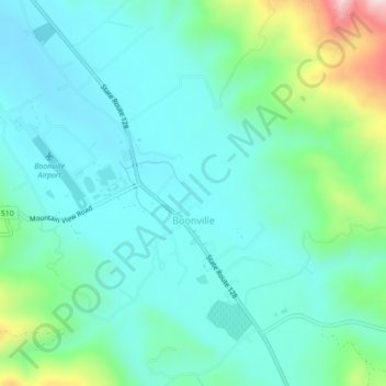
Name: Boonville topographic map, elevation, terrain.
Location: Boonville, Mendocino County, California, United States (38.99457 -123.39294 39.02857 -123.35086)
Average elevation: 551 ft
Minimum elevation: 295 ft
Maximum elevation: 1,490 ft
Mendocino County trails, hiking, mountain biking, running and outdoor activities
Other topographic maps
Click on a map to view its topography, its elevation and its terrain.
Fort Bragg
United States > California > Mendocino County
Fort Bragg is a city along the North Coast of California in Mendocino County. The city is 24 miles (39 km) west of Willits, at an elevation of 85 feet (26 m). Its population was 6,983 at the 2020 census.
Average elevation: 75 ft
Fort Bragg
United States > California > Mendocino County
Fort Bragg is a city along the North Coast of California in Mendocino County. The city is 24 miles (39 km) west of Willits, at an elevation of 85 feet (26 m). Its population was 6,983 at the 2020 census.
Average elevation: 75 ft
Brooktrails
United States > California > Mendocino County
Brooktrails is in central Mendocino County, occupying hills to the west of Little Lake Valley. The fire department and golf course lie at an elevation of 1,634 feet (498 m), but the community's western edge rises to nearly 3,000 feet (910 m). It is 3 miles (5 km) north of Willits. According to the United…
Average elevation: 1,867 ft
Fort Bragg
United States > California > Mendocino County
Fort Bragg is a city along the North Coast of California in Mendocino County. The city is 24 miles (39 km) west of Willits, at an elevation of 85 feet (26 m). Its population was 6,983 at the 2020 census.
Average elevation: 75 ft
Anderson Valley
United States > California > Mendocino County
The climate is tempered by cool marine air. Steep hills and mountains surround rolling to nearly level alluvial terraces. The dominant natural vegetation is a mixed forest of Coast Redwood, various native oak varieties, and Douglas fir. Elevation ranges from sea level to 2,500 feet (760 m). The average annual…
Average elevation: 423 ft
Redwood Valley
United States > California > Mendocino County
Redwood Valley (formerly Basil) is a census-designated place (CDP) in Mendocino County, California, United States. It is located 9 miles (14 km) north of Ukiah, the county seat, at an elevation of 722 feet (220 m), and comprises the northern portion of the Ukiah Valley. It is about 15 miles (24 km) southeast…
Average elevation: 807 ft
Potter Valley
United States > California > Mendocino County
Potter Valley is a census-designated place in Mendocino County, California, United States. It is located 18 miles (29 km) north-northeast of Ukiah, at an elevation of 948 feet (289 m) at the headwaters of the East Fork Russian River. The CDP population was 665 at the 2020 census.
Average elevation: 1,040 ft