
Kepulauan Natuna Selatan topographic map
Interactive map
Click on the map to display elevation.
About this map
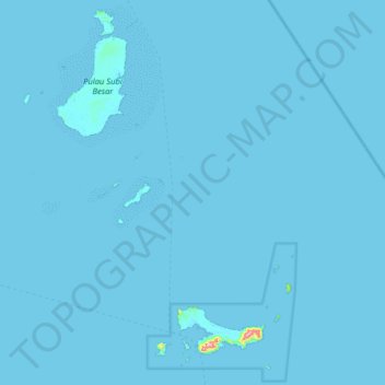
Name: Kepulauan Natuna Selatan topographic map, elevation, terrain.
Location: Kepulauan Natuna Selatan, Riau Islands, Indonesia (2.43000 108.68000 3.07000 109.32000)
Average elevation: 3 ft
Minimum elevation: -3 ft
Maximum elevation: 1,263 ft
Other topographic maps
Click on a map to view its topography, its elevation and its terrain.
Bintan Island
Indonesia > Riau Islands > Bintan
Bintan, is the largest among the 3,200 islands of Riau Archipelago and is located 10 kilometres (6.2 mi) east of the Batam Island. It has a coast line of 105 kilometres (65 mi) and has rolling topography in its landform. The Riau Islands are a province of Indonesia, which encompassed the Riau Archipelago,…
Average elevation: 20 ft
Natuna
The airport resides at an elevation of 2 metres (6 ft 7 in) above mean sea level. It has one runway designated 18/36 with an asphalt surface measuring 2,560 m x 32 m (8,399 ft × 105 ft). The runway is planned to be widened to 80 m in 2020. Moreover, the airport has an apron measuring 120 m x 60 m and a…
Average elevation: 3 ft