
Azcapotzalco topographic map
Interactive map
Click on the map to display elevation.
Azcapotzalco
The municipality of Azcapotzalco is in the Valley of Mexico with its eastern half on the lakebed of the former Lake Texcoco and the west on more solid ground. The historic center is on the former shoreline of this lake. The average altitude is 2240 meters above sea level. Politically, the municipality extends over 34.5km2 in the northwest of the Federal District of Mexico City, bordering the municipality of Gustavo A. Madero, Cuauhtémoc, Miguel Hidalgo along with the municipalities of Tlalnepantla de Baz, and Naucalpan in the State of Mexico.
About this map
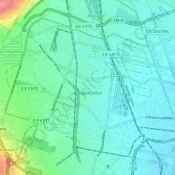
Name: Azcapotzalco topographic map, elevation, terrain.
Location: Azcapotzalco, Mexico City, Mexico (19.45643 -99.22113 19.51513 -99.14305)
Average elevation: 7,372 ft
Minimum elevation: 7,326 ft
Maximum elevation: 7,575 ft
Other topographic maps
Click on a map to view its topography, its elevation and its terrain.
Xochimilco
Much of the borough's land is former lakebed. Its main elevations include Xochitepec and Tlacualleli mountains along with two volcanoes named Teutli and Tzompol. It contains two natural rivers called Santiago and Tepapantla along with the various canals, which is what is left of the lake. The elevated areas of…
Average elevation: 7,352 ft