
Tibesti topographic map
Interactive map
Click on the map to display elevation.
About this map
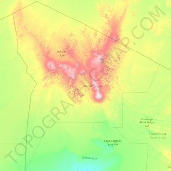
Name: Tibesti topographic map, elevation, terrain.
Location: Tibesti, Chad (16.94907 14.99858 23.49750 21.02467)
Average elevation: 2,178 ft
Minimum elevation: 545 ft
Maximum elevation: 10,853 ft
Other topographic maps
Click on a map to view its topography, its elevation and its terrain.
Emi Koussi
Emi Koussi (also known as Emi Koussou) is a high pyroclastic shield volcano that lies at the southeast end of the Tibesti Mountains in the central Sahara, in the northern Borkou Region of northern Chad. The highest mountain of the Sahara, the volcano is one of several in the Tibesti range, and reaches an…
Average elevation: 9,537 ft