
الزهور topographic map
Interactive map
Click on the map to display elevation.
About this map
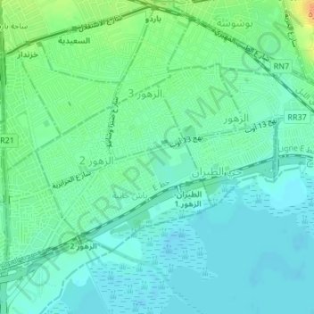
Name: الزهور topographic map, elevation, terrain.
Location: الزهور, Tunis, Tunisia (36.78632 10.12261 36.80240 10.15520)
Average elevation: 43 ft
Minimum elevation: 10 ft
Maximum elevation: 125 ft
Other topographic maps
Click on a map to view its topography, its elevation and its terrain.
Sidi Boussaid
Tunisia > Tunis > Sidi Boussaid
Sidi Boussaid, سيدي بو سعيد, Carthage, Tunis, 2026, Tunisia
Average elevation: 43 ft