
Polk City topographic map
Interactive map
Click on the map to display elevation.
About this map
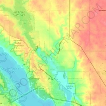
Name: Polk City topographic map, elevation, terrain.
Location: Polk City, Polk County, Iowa, 50226, United States (41.74625 -93.74393 41.82796 -93.67747)
Average elevation: 928 ft
Minimum elevation: 820 ft
Maximum elevation: 1,033 ft
Polk County trails, hiking, mountain biking, running and outdoor activities
Other topographic maps
Click on a map to view its topography, its elevation and its terrain.