Geolocate

Baja'I topographic map

Interactive map

Click on the map to display elevation.

About this map

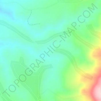
Name: Baja'I topographic map, elevation, terrain.

Location: Baja'I, Guraghe, Southern Nations, Ethiopia (8.00667 37.85667 8.02667 37.87667)

Average elevation: 7,129 ft

Minimum elevation: 6,864 ft

Maximum elevation: 7,733 ft

Other topographic maps

Click on a map to view its topography, its elevation and its terrain.

Worabe

Ethiopia > Southern Nations > Worabe

Worabe, Guraghe, Southern Nations, Ethiopia

Average elevation: 6,936 ft

Gidole

Ethiopia > Southern Nations > Gidole

Gidole, Derashe Special Woreda, Southern Nations, Ethiopia

Average elevation: 6,647 ft

Wolayita

Ethiopia > Southern Nations

Wolayita, Southern Nations, Ethiopia

Average elevation: 5,207 ft

Durame

Ethiopia > Southern Nations > Durame

Durame, Kembata Alaba Tembaro, Southern Nations, Ethiopia

Average elevation: 7,037 ft

Bona Qabelanka

Ethiopia > Southern Nations > Bona Qabelanka

Bona Qabelanka, Sidama, Southern Nations, Ethiopia

Average elevation: 6,880 ft

Kombo

Ethiopia > Southern Nations > Kombo

Kombo, Guraghe, Southern Nations, Ethiopia

Average elevation: 9,341 ft

Elma

Ethiopia > Southern Nations

Elma, South Omo, Southern Nations, Ethiopia

Average elevation: 2,300 ft

Yirga Ch'Efe Bota

Ethiopia > Southern Nations > Yirga Cheffe

Yirga Ch'Efe Bota, Yirga Cheffe, Gedeo, Southern Nations, Ethiopia

Average elevation: 7,329 ft

Kasha

Ethiopia > Southern Nations > Kasha

Kasha, Keffa, Southern Nations, Ethiopia

Average elevation: 5,722 ft