
Chiriquí topographic map
Interactive map
Click on the map to display elevation.
About this map
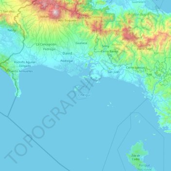
Name: Chiriquí topographic map, elevation, terrain.
Location: Chiriquí, Panama (7.18788 -83.05172 8.92228 -81.51150)
Average elevation: 722 ft
Minimum elevation: -3 ft
Maximum elevation: 11,207 ft
Other topographic maps
Click on a map to view its topography, its elevation and its terrain.
Embalse Río Caldera
Panama > Chiriquí > Distrito de Boquete > Alto Boquete
Average elevation: 3,537 ft
Panama Pacifico
Panama > Panamá Oeste > Distrito Arraiján > Veracruz > Panama Pacifico
Average elevation: 79 ft
Pigeon Key (cayo Paloma)
Panama > Comarca Ngäbe Buglé > Distrito Kusapín > Pigeon Key (cayo Paloma)
Average elevation: 56 ft
Fort Sherman
Panama > Colón > Distrito Colón > Cristóbal
Between 1966 and 1979, 1,160 sounding rockets with maximum flight altitudes of 99 kilometres were launched from Fort Sherman. Fort Sherman was used in the filming of the 2008 James Bond film Quantum of Solace.
Average elevation: 23 ft