
Egypt Lake-Leto topographic map
Interactive map
Click on the map to display elevation.
Egypt Lake-Leto
Egypt Lake-Leto is located in northwestern Hillsborough County at 28°0′55″N 82°30′26″W / 28.01528°N 82.50722°W / 28.01528; -82.50722 (28.015396, -82.507311), 7 miles (11 km) northwest of downtown Tampa. The elevation for the CDP is 45 feet (14 m) above sea level.
About this map
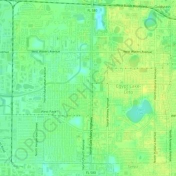
Name: Egypt Lake-Leto topographic map, elevation, terrain.
Average elevation: 49 ft
Minimum elevation: 13 ft
Maximum elevation: 75 ft
Hillsborough County trails, hiking, mountain biking, running and outdoor activities
Other topographic maps
Click on a map to view its topography, its elevation and its terrain.
Alafia River Estates
United States > Florida > Hillsborough County > Riverview
Average elevation: 30 ft
River Arts District
United States > Florida > Hillsborough County > Tampa > Clarkes
Average elevation: 33 ft
Green Grass Acres
United States > Florida > Hillsborough County > Citrus Park
Average elevation: 36 ft
Town of Citrus Park
United States > Florida > Hillsborough County > Citrus Park
Average elevation: 43 ft
East Lake Park
United States > Florida > Hillsborough County > East Lake-Orient Park
Average elevation: 43 ft
Idlewild on the Hillsborough
United States > Florida > Hillsborough County > Tampa
Average elevation: 46 ft
Club Manor East of Grand Hampton
United States > Florida > Hillsborough County > Tampa
Average elevation: 56 ft
Northpointe at Bayshore
United States > Florida > Hillsborough County > Tampa
Average elevation: 13 ft
Hillsborough River Estates
United States > Florida > Hillsborough County > Tampa
Average elevation: 46 ft
Morningside Heights
United States > Florida > Hillsborough County > Plant City
Average elevation: 131 ft