
Hope Town topographic map
Interactive map
Click on the map to display elevation.
About this map
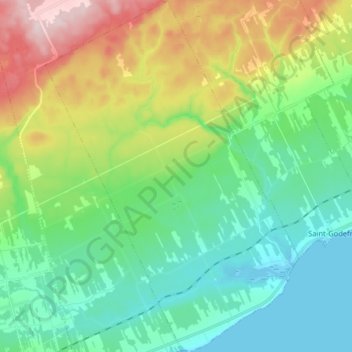
Name: Hope Town topographic map, elevation, terrain.
Average elevation: 315 ft
Minimum elevation: -3 ft
Maximum elevation: 1,043 ft
Other topographic maps
Click on a map to view its topography, its elevation and its terrain.
New Richmond
Canada > Quebec > Bonaventure
New Richmond, Bonaventure, Gaspésie–Îles-de-la-Madeleine, Quebec, G0C 2B0, Canada
Average elevation: 276 ft
Cascapédia-Saint-Jules
Canada > Quebec > Bonaventure > Cascapédia-Saint-Jules
Cascapédia-Saint-Jules, Bonaventure, Gaspésie–Îles-de-la-Madeleine, Quebec, G0C 1T0, Canada
Average elevation: 528 ft