
Redfield topographic map
Interactive map
Click on the map to display elevation.
About this map
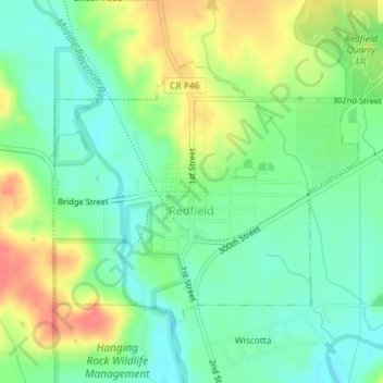
Name: Redfield topographic map, elevation, terrain.
Location: Redfield, Dallas County, Iowa, United States (41.58151 -94.20907 41.59999 -94.18018)
Average elevation: 978 ft
Minimum elevation: 899 ft
Maximum elevation: 1,099 ft
Dallas County trails, hiking, mountain biking, running and outdoor activities
Other topographic maps
Click on a map to view its topography, its elevation and its terrain.