
Teton Village topographic map
Interactive map
Click on the map to display elevation.
About this map
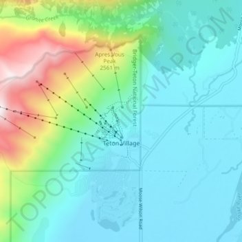
Name: Teton Village topographic map, elevation, terrain.
Location: Teton Village, Teton County, Wyoming, 83025, United States (43.57385 -110.87976 43.61177 -110.80548)
Average elevation: 7,621 ft
Minimum elevation: 6,253 ft
Maximum elevation: 10,430 ft
Teton County trails, hiking, mountain biking, running and outdoor activities
Other topographic maps
Click on a map to view its topography, its elevation and its terrain.
Rocky Mountains
United States > Wyoming > Teton County
Agriculture and forestry are major industries. Agriculture includes dryland and irrigated farming and livestock grazing. Livestock are frequently moved between high-elevation summer pastures and low-elevation winter pastures, a practice known as transhumance.
Average elevation: 7,520 ft
Buck Mountain
United States > Wyoming > Teton County
Buck Mountain (elevation: 11,943 feet (3,640 m)) is a mountain located in the Teton Range, Grand Teton National Park, Wyoming, immediately southeast of Grand Teton.
Average elevation: 10,262 ft
Rendezvous Mountain
United States > Wyoming > Teton County > Teton Village
Average elevation: 9,281 ft