
Make a donation
Gear up for your next adventure:
As an Amazon Associate, this site earns from qualifying purchases at no extra cost to you.
Santa Cruz Province topographic map
Click on the map to display elevation.
Gear up for your next adventure:
As an Amazon Associate, this site earns from qualifying purchases at no extra cost to you.
Santa Cruz Province
From the centre to the Atlantic coast in the east, the landscape is dominated by plateaus. These plateaus are made up of basalt rock occur in stepped sequences. The plateaus are of different ages with the older –of Neogene and Paleogene age– being located at higher elevations than Pleistocene and Holocene lava plateaus and outcrops. There are isolated pockets of hills and depressions within this region. In Gran Bajo de San Julián, the Laguna del Carbón is 105 meters below sea level, and is the lowest point in the Western and Southern Hemispheres. On the Atlantic coast, it is characterised by cliffs.
Make a donation
Gear up for your next adventure:
As an Amazon Associate, this site earns from qualifying purchases at no extra cost to you.
About this map
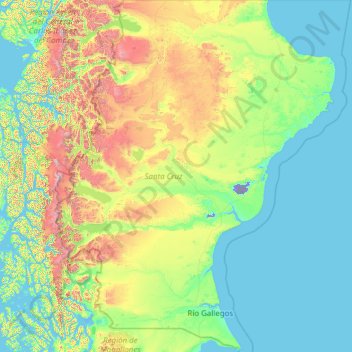
Name: Santa Cruz Province topographic map, elevation, terrain.
Location: Santa Cruz Province, Argentina (-52.39760 -73.56054 -45.99973 -65.71818)
Average elevation: 1,148 ft
Minimum elevation: -171 ft
Maximum elevation: 11,657 ft
Make a donation
Gear up for your next adventure:
As an Amazon Associate, this site earns from qualifying purchases at no extra cost to you.
Other topographic maps
Click on a map to view its topography, its elevation and its terrain.