
Make a donation
Gear up for your next adventure:
As an Amazon Associate, this site earns from qualifying purchases at no extra cost to you.
Philadelphia topographic map
Click on the map to display elevation.
Make a donation
Gear up for your next adventure:
As an Amazon Associate, this site earns from qualifying purchases at no extra cost to you.
Philadelphia
Philadelphia, located at the confluence of the Delaware and Schuylkill Rivers, features a diverse topography characterized by its gentle slopes and valleys. The city lies on the Atlantic Seaboard Fall Line, transitioning from the flat Coastal Plain to the more rugged Piedmont region. This unique geographical positioning results in a landscape that includes expansive tidal areas and rolling hills, with elevations generally ranging from sea level along the rivers to around 446 feet in the Chestnut Hill neighborhood. The Schuylkill River has carved a steep valley as it flows through the Piedmont, contrasting with the relatively flat terrain of southern New Jersey. This gradual change in elevation and the presence of numerous creeks and parks, such as Fairmount Park, further enhance Philadelphia's natural beauty and accessibility. The interplay between water and landforms has not only shaped the physical landscape but also played a crucial role in the city's historical development.
Make a donation
Gear up for your next adventure:
As an Amazon Associate, this site earns from qualifying purchases at no extra cost to you.
About this map
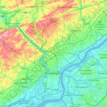
Name: Philadelphia topographic map, elevation, terrain.
Average elevation: 144 ft
Minimum elevation: -131 ft
Maximum elevation: 509 ft
Philadelphia County trails, hiking, mountain biking, running and outdoor activities
Make a donation
Gear up for your next adventure:
As an Amazon Associate, this site earns from qualifying purchases at no extra cost to you.
Other topographic maps
Click on a map to view its topography, its elevation and its terrain.
Bartram's Garden
United States > Pennsylvania > Philadelphia County > Philadelphia
Average elevation: 43 ft
East Passyunk Community Recreation Center
United States > Pennsylvania > Philadelphia County > Philadelphia
Average elevation: 30 ft
Strawberry Mansion
United States > Pennsylvania > Philadelphia County > Philadelphia
Average elevation: 102 ft
Pastorius Park
United States > Pennsylvania > Philadelphia County > Philadelphia
Average elevation: 354 ft
Make a donation
Gear up for your next adventure:
As an Amazon Associate, this site earns from qualifying purchases at no extra cost to you.