
Le Vésinet topographic map
Interactive map
Click on the map to display elevation.
Le Vésinet
The terrain is an alluvial plain ranging in altitude from 28 meters near Le Pecq to 45 meters at the end of the Route de Montesson, with a gentle slope from northeast to southwest.
About this map
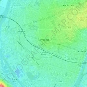
Name: Le Vésinet topographic map, elevation, terrain.
Average elevation: 121 ft
Minimum elevation: 56 ft
Maximum elevation: 302 ft
Other topographic maps
Click on a map to view its topography, its elevation and its terrain.