
Wijk bij Duurstede topographic map
Interactive map
Click on the map to display elevation.
About this map
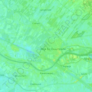
Name: Wijk bij Duurstede topographic map, elevation, terrain.
Location: Wijk bij Duurstede, Utrecht, Nederland (51.95492 5.25627 52.00008 5.39495)
Average elevation: 16 ft
Minimum elevation: -13 ft
Maximum elevation: 49 ft
Other topographic maps
Click on a map to view its topography, its elevation and its terrain.
Cothen
Nederland > Utrecht > Wijk bij Duurstede
Cothen, Wijk bij Duurstede, Utrecht, Nederland
Average elevation: 16 ft
Langbroek
Nederland > Utrecht > Wijk bij Duurstede
Langbroek, Wijk bij Duurstede, Utrecht, Nederland
Average elevation: 23 ft
Kasteel Duurstede
Nederland > Utrecht > Wijk bij Duurstede
Kasteel Duurstede, Langs de Wal, Binnenstad, Wijk bij Duurstede, Utrecht, Nederland, 3961BD, Nederland
Average elevation: 20 ft