
Harzé topographic map
Interactive map
Click on the map to display elevation.
About this map
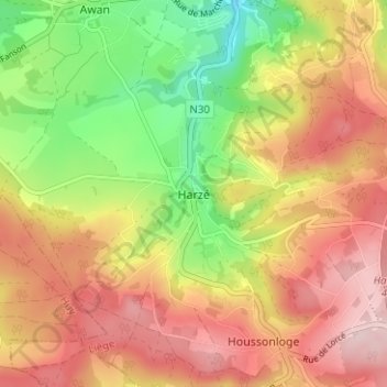
Name: Harzé topographic map, elevation, terrain.
Location: Harzé, Aywaille, Luik, Wallonië, 4920, België (50.42091 5.64727 50.46091 5.68727)
Average elevation: 971 ft
Minimum elevation: 538 ft
Maximum elevation: 1,339 ft
Other topographic maps
Click on a map to view its topography, its elevation and its terrain.
Remouchamps
België > Luik > Luik > Aywaille
Remouchamps, Aywaille, Luik, Wallonië, 4920, België
Average elevation: 728 ft