
Make a donation
Gear up for your next adventure:
As an Amazon Associate, this site earns from qualifying purchases at no extra cost to you.
Ninglinspo topographic map
Click on the map to display elevation.
Make a donation
Gear up for your next adventure:
As an Amazon Associate, this site earns from qualifying purchases at no extra cost to you.
Ninglinspo
De Ninglinspo is de enige bergrivier van België. Zij stroomt door een gebied dat sinds 1949 beschermd gebied is. De loop van de Ninglinspo daalt van 420 meter naar 170 meter, is 3 kilometer lang en heeft hierdoor een gemiddeld verval van 8%. Ze overbrugt een hoogteverschil van 250 meter. De grootste waterval in de rivier is de Waterval van de Chaudière, ze mondt uit in de Amblève net nadat deze in de Fonds de Quarreux overgaat. Door de erosie van het snelle en wervelende water ontstonden er enkele diepe, nauwe uithollingen die de bassins onderling verbinden. Deze bassins kregen poëtische namen zoals "bad van het hert", "Bad van Diana", "Bubbels van de ketel", "Bad van de waternimfen", "Bad van Venus",...
Make a donation
Gear up for your next adventure:
As an Amazon Associate, this site earns from qualifying purchases at no extra cost to you.
About this map
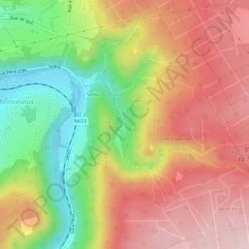
Name: Ninglinspo topographic map, elevation, terrain.
Average elevation: 991 ft
Minimum elevation: 472 ft
Maximum elevation: 1,424 ft
Make a donation
Gear up for your next adventure:
As an Amazon Associate, this site earns from qualifying purchases at no extra cost to you.
Other topographic maps
Click on a map to view its topography, its elevation and its terrain.