
Dir topographic map
Interactive map
Click on the map to display elevation.
About this map
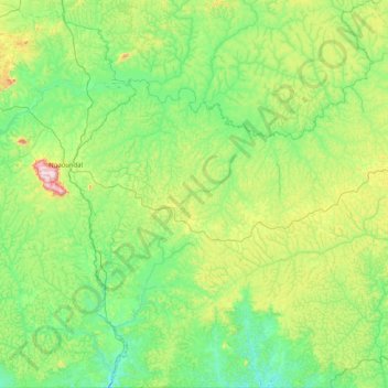
Name: Dir topographic map, elevation, terrain.
Location: Dir, Mbéré, Région de l'Adamaoua, Cameroun (6.00107 13.28642 6.81124 14.07060)
Average elevation: 2,999 ft
Minimum elevation: 2,539 ft
Maximum elevation: 4,560 ft
Other topographic maps
Click on a map to view its topography, its elevation and its terrain.
Meiganga
Cameroun > Région de l'Adamaoua > Mbéré
Meiganga, Mbéré, Région de l'Adamaoua, Cameroun
Average elevation: 3,264 ft
Bougi
Cameroun > Région de l'Adamaoua > Mbéré > Meiganga
Bougi, Meiganga, Mbéré, Région de l'Adamaoua, Cameroun
Average elevation: 3,363 ft
Ngazi
Cameroun > Région de l'Adamaoua > Mbéré > Meiganga
Ngazi, Meiganga, Mbéré, Région de l'Adamaoua, Cameroun
Average elevation: 3,238 ft