
Hemel Hempstead topographic map
Interactive map
Click on the map to display elevation.
About this map
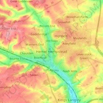
Name: Hemel Hempstead topographic map, elevation, terrain.
Average elevation: 427 ft
Minimum elevation: 230 ft
Maximum elevation: 584 ft
Other topographic maps
Click on a map to view its topography, its elevation and its terrain.
Berkhamsted
United Kingdom > England > Hertfordshire > Dacorum > Berkhamsted
The layout of Berkhamsted's centre is typical of a medieval market settlement: the linear High Street (aligned on the Akeman Street) forms the spine of the town (roughly aligned east–west), from which extend medieval burgage plots (to the north and south). The surviving burgage plot layout is the result of a…
Average elevation: 466 ft