
Rüsselsheim am Main topographic map
Interactive map
Click on the map to display elevation.
About this map
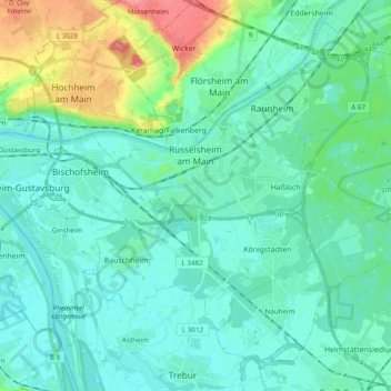
Name: Rüsselsheim am Main topographic map, elevation, terrain.
Location: Rüsselsheim am Main, Kreis Groß-Gerau, Hesse, 65428, Germany (49.93874 8.35636 50.02530 8.54934)
Average elevation: 315 ft
Minimum elevation: 266 ft
Maximum elevation: 509 ft
Other topographic maps
Click on a map to view its topography, its elevation and its terrain.
Rüsselsheim am Main
Germany > Hesse > Kreis Groß-Gerau > Rüsselsheim am Main
Rüsselsheim am Main, Kreis Groß-Gerau, Hesse, 65428, Germany
Average elevation: 305 ft
Main
Germany > Hesse > Kreis Groß-Gerau > Bischofsheim
Main, Bischofsheim, Kreis Groß-Gerau, Hesse, Germany
Average elevation: 325 ft