
Make a donation
Gear up for your next adventure:
As an Amazon Associate, this site earns from qualifying purchases at no extra cost to you.
Lake Wylie topographic map
Click on the map to display elevation.
Make a donation
Gear up for your next adventure:
As an Amazon Associate, this site earns from qualifying purchases at no extra cost to you.
Lake Wylie
Lake Wylie is located on a peninsula along the shore of Lake Wylie in the Piedmont of both North and South Carolina, at 35°6′22″N 81°3′25″W / 35.10611°N 81.05694°W / 35.10611; -81.05694 (35.105973, -81.056978). According to the United States Census Bureau, the CDP has a total area of 4.7 square miles (12 km2), of which 3.5 square miles (9.1 km2) is land and 1.3 square miles (3.4 km2) (26.58%) is water. The average elevation of the town is 512 feet.
Make a donation
Gear up for your next adventure:
As an Amazon Associate, this site earns from qualifying purchases at no extra cost to you.
About this map
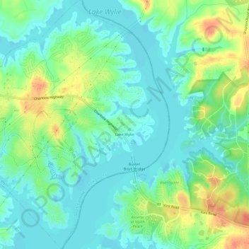
Name: Lake Wylie topographic map, elevation, terrain.
Location: Lake Wylie, York County, South Carolina, United States (35.08726 -81.07738 35.13349 -81.03247)
Average elevation: 617 ft
Minimum elevation: 568 ft
Maximum elevation: 722 ft
York County trails, hiking, mountain biking, running and outdoor activities
Make a donation
Gear up for your next adventure:
As an Amazon Associate, this site earns from qualifying purchases at no extra cost to you.
Other topographic maps
Click on a map to view its topography, its elevation and its terrain.
Make a donation
Gear up for your next adventure:
As an Amazon Associate, this site earns from qualifying purchases at no extra cost to you.
Boyd Hill
United States > South Carolina > York County > Rock Hill > Boyd Hill
Average elevation: 630 ft
Rock Hill
United States > South Carolina > York County > Rock Hill > Rock Hill
Average elevation: 607 ft