
Moundville topographic map
Interactive map
Click on the map to display elevation.
About this map
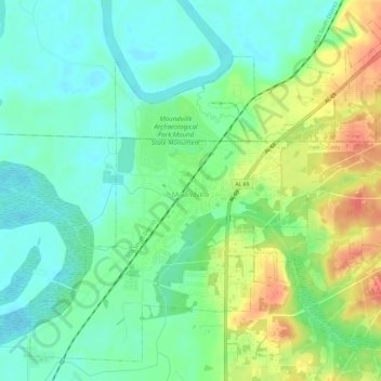
Name: Moundville topographic map, elevation, terrain.
Location: Moundville, Hale County, Alabama, United States (32.97587 -87.65518 33.02029 -87.59611)
Average elevation: 164 ft
Minimum elevation: 95 ft
Maximum elevation: 289 ft
Other topographic maps
Click on a map to view its topography, its elevation and its terrain.
Newbern
United States > Alabama > Hale County
Newbern, Hale County, Alabama, United States
Average elevation: 171 ft
Prairieville
United States > Alabama > Hale County > Prairieville
Prairieville, Hale County, Alabama, United States
Average elevation: 167 ft