
Frauenau topographic map
Interactive map
Click on the map to display elevation.
About this map
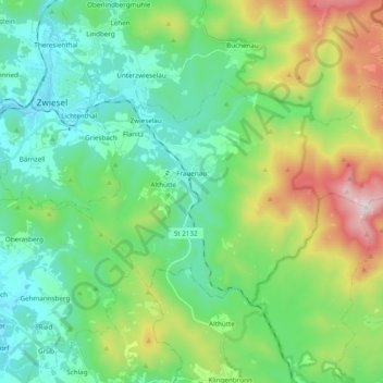
Name: Frauenau topographic map, elevation, terrain.
Location: Frauenau, Landkreis Regen, Bavaria, 94258, Germany (48.94660 13.22460 49.02050 13.41748)
Average elevation: 2,605 ft
Minimum elevation: 1,811 ft
Maximum elevation: 4,718 ft
Other topographic maps
Click on a map to view its topography, its elevation and its terrain.
Kirchweg
Germany > Bavaria > Landkreis Regen
Kirchweg, Zachenberg, Ruhmannsfelden (VGem), Landkreis Regen, Bavaria, 94239, Germany
Average elevation: 1,919 ft
Bayerisch Eisenstein
Germany > Bavaria > Landkreis Regen
Bayerisch Eisenstein, Landkreis Regen, Bavaria, 94252, Germany
Average elevation: 3,015 ft