
Hopkinton topographic map
Interactive map
Click on the map to display elevation.
About this map
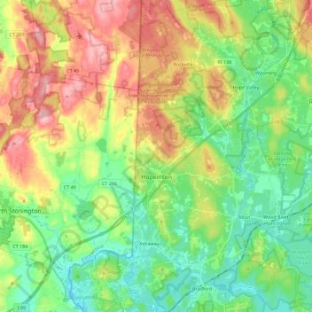
Name: Hopkinton topographic map, elevation, terrain.
Location: Hopkinton, South County, Rhode Island, United States (41.38647 -71.80348 41.55417 -71.68724)
Average elevation: 207 ft
Minimum elevation: 7 ft
Maximum elevation: 531 ft
South County trails, hiking, mountain biking, running and outdoor activities
Other topographic maps
Click on a map to view its topography, its elevation and its terrain.
Green Hill Point
United States > Rhode Island > South County > South Kingstown > Green Hill
Average elevation: 7 ft
Newton Swamp Management Area
United States > Rhode Island > South County > Westerly
Average elevation: 72 ft