
Make a donation
Gear up for your next adventure:
As an Amazon Associate, this site earns from qualifying purchases at no extra cost to you.
Ashburn topographic map
Click on the map to display elevation.
Make a donation
Gear up for your next adventure:
As an Amazon Associate, this site earns from qualifying purchases at no extra cost to you.
Ashburn
Ashburn is located at 39°02′37″N 077°29′15″W / 39.04361°N 77.48750°W / 39.04361; -77.48750 (39.0437192, −77.4874899) and its average elevation is 295 feet (90 m) above sea level. According to the 2010 United States Census, the CDP has a total area of 17.287 square miles (44.77 km2), of which 17.025 square miles (44.09 km2) is land and 0.262 square miles (0.68 km2) is water. Ashburn is located between Washington Dulles International Airport and Leesburg, the county seat of Loudoun County.
Make a donation
Gear up for your next adventure:
As an Amazon Associate, this site earns from qualifying purchases at no extra cost to you.
About this map
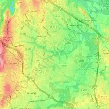
Name: Ashburn topographic map, elevation, terrain.
Location: Ashburn, Loudoun County, Virginia, United States (38.98815 -77.52292 39.07145 -77.43125)
Average elevation: 282 ft
Minimum elevation: 118 ft
Maximum elevation: 472 ft
Loudoun County trails, hiking, mountain biking, running and outdoor activities
Make a donation
Gear up for your next adventure:
As an Amazon Associate, this site earns from qualifying purchases at no extra cost to you.