Geolocate

Montpellier topographic map

Interactive map

Click on the map to display elevation.

Montpellier

Montpellier's highest point is the Place du Peyrou, at an altitude of 57 m (187 ft). The city is built on two hills, Montpellier and Montpelliéret, thus some of its streets have great differences of altitude. Some of its streets are also very narrow and old, which gives it a more intimate feel.

Wikipedia (CC-BY-SA 3.0)

About this map

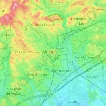
Name: Montpellier topographic map, elevation, terrain.

Location: Montpellier, Hérault, Occitania, Metropolitan France, France (43.56671 3.80706 43.65336 3.94132)

Average elevation: 135 ft

Minimum elevation: -3 ft

Maximum elevation: 423 ft

Other topographic maps

Click on a map to view its topography, its elevation and its terrain.

Ayez

France > Occitania > Hérault > Olargues

Average elevation: 1,063 ft

Bordevieille

France > Occitania > Hérault > Riols

Average elevation: 2,306 ft

Boirargues

France > Occitania > Hérault > Lattes

Average elevation: 46 ft

Carol

France > Occitania > Hérault > Octon

Average elevation: 889 ft

Roc du Caroux

France > Occitania > Hérault > Rosis

Average elevation: 2,398 ft

Réals

France > Occitania > Hérault > Cessenon-sur-Orb

Average elevation: 292 ft

Seilhols

France > Occitania > Hérault > Colombières-sur-Orb

Average elevation: 1,424 ft

Belot

France > Occitania > Hérault > La Salvetat-sur-Agout

Average elevation: 2,470 ft

Colline de Chabanette

France > Occitania > Hérault > Sète

Average elevation: 92 ft

Les Nières

France > Occitania > Hérault > Saint-Gervais-sur-Mare

Average elevation: 1,542 ft

Tarassac

France > Occitania > Hérault > Mons

Average elevation: 922 ft

Riols

France > Occitania > Hérault > Graissessac

Average elevation: 1,637 ft

La Quille

France > Occitania > Hérault > Les Plans

Average elevation: 2,110 ft

Montpellier

France > Occitania > Hérault > Montpellier

Average elevation: 236 ft