
Tehran topographic map
Interactive map
Click on the map to display elevation.
About this map
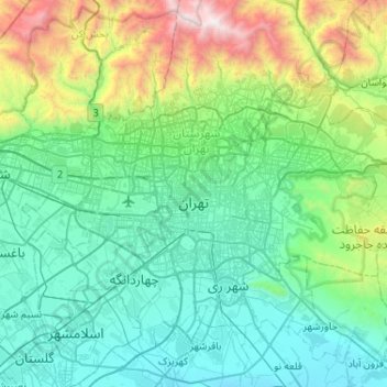
Name: Tehran topographic map, elevation, terrain.
Average elevation: 5,049 ft
Minimum elevation: 3,202 ft
Maximum elevation: 12,936 ft
As the city has a large area, with significant differences in elevation among various districts, the weather is often cooler in the hilly north than in the flat southern part of Tehran. For instance, the 17.3 km (10.7 mi) Valiasr Street runs from Tehran's railway station at 1,117 m (3,665 ft) elevation above sea level in the south of the city to Tajrish Square at 1712.6 m (5612.3 ft) elevation above sea level in the north. However, the elevation can even rise up to 2,000 m (6,600 ft) at the end of Velenjak in northern Tehran. The sparse texture, the existence of old gardens, orchards, green spaces along the highways and the lack of industrial activities in the north of the city have helped the air in the northern areas to be 2 to 3 degrees Celsius cooler than the southern areas of the city.
Other topographic maps
Click on a map to view its topography, its elevation and its terrain.
بوستان سیما
Iran > Tehran County > Tehran
بوستان سیما, Saeei, District 6, Tehran, بخش مرکزی شهرستان تهران, Tehran County, Tehran Province, Iran
Average elevation: 4,514 ft
دهستان سیاهرود
دهستان سیاهرود, بخش مرکزی شهرستان تهران, Tehran County, Tehran Province, Iran
Average elevation: 5,184 ft
Laleh Park
Iran > Tehran County > Tehran
Laleh Park, District 6, شهرداری منطقه شش ناحیه یک, Tehran, بخش مرکزی شهرستان تهران, Tehran County, Tehran Province, Iran
Average elevation: 4,085 ft
Milad Tower
Iran > Tehran County > Tehran
Milad Tower, مرکز همایش های برج میلاد, Kuy Nasr, District 2, Tehran, بخش مرکزی شهرستان تهران, Tehran County, Tehran Province, 14736-56857, Iran
Average elevation: 4,573 ft
Dardasht
Iran > Tehran County > Tehran
Dardasht, District 8, Tehran, بخش مرکزی شهرستان تهران, Tehran County, Tehran Province, Iran
Average elevation: 4,249 ft
Arazi Abas Abad
Iran > Tehran County > Tehran
Arazi Abas Abad, District 3, Tehran, بخش مرکزی شهرستان تهران, Tehran County, Tehran Province, Iran
Average elevation: 4,521 ft
شهرداری منطقه شش ناحیه یک
Iran > Tehran County > Tehran
شهرداری منطقه شش ناحیه یک, Tehran, بخش مرکزی شهرستان تهران, Tehran County, 15989-35611, Iran
Average elevation: 4,022 ft
Sa'i Park
Iran > Tehran County > Tehran
Sa'i Park, District 6, شهرداری منطقه شش ناحیه یک, Tehran, بخش مرکزی شهرستان تهران, Tehran County, Iran
Average elevation: 4,423 ft