
Tehran topographic map
Click on the map to display elevation.
Tehran
Tehran, located in the northern part of Iran, is set against the backdrop of the Alborz mountain range, which towers prominently to the north. The city itself is perched at approximately 3,750 feet (1,143 meters) above sea level, providing a striking contrast between its urban landscape and the rugged terrain nearby. The topography of Tehran features a mix of flat urban areas interspersed with hilly regions, particularly in the north where wealthier neighborhoods reside. This northern expanse transitions rapidly into steep slopes leading to the Alborz mountains, which reach elevations exceeding 18,000 feet (5,500 meters) at their highest peaks, such as Mount Damavand, Iran's tallest mountain. The climate is typically temperate, with warm summers and cold winters, making the surrounding mountains a popular destination for outdoor activities like skiing in winter and hiking in summer.
About this map
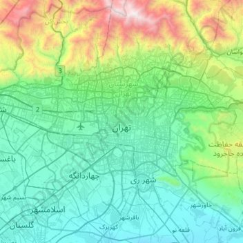
Name: Tehran topographic map, elevation, terrain.
Average elevation: 5,049 ft
Minimum elevation: 3,202 ft
Maximum elevation: 12,936 ft
Other topographic maps
Click on a map to view its topography, its elevation and its terrain.