
Woodland Park topographic map
Interactive map
Click on the map to display elevation.
Woodland Park
The area is characterized by the abundance of large granite rocks and alpine meadows, as well as its consistently high elevation ranging between 8,200 and 10,000 feet above sea level. The climate is considered arid which causes the surrounding forests to become very dry, posing a significant fire threat in combination with a large proportion of lightning strikes and high mountain winds. Fire restrictions are common.
About this map
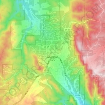
Name: Woodland Park topographic map, elevation, terrain.
Average elevation: 8,701 ft
Minimum elevation: 8,022 ft
Maximum elevation: 9,462 ft
Teller County trails, hiking, mountain biking, running and outdoor activities
Other topographic maps
Click on a map to view its topography, its elevation and its terrain.