
Make a donation
Gear up for your next adventure:
As an Amazon Associate, this site earns from qualifying purchases at no extra cost to you.
Minneapolis topographic map
Click on the map to display elevation.
Make a donation
Gear up for your next adventure:
As an Amazon Associate, this site earns from qualifying purchases at no extra cost to you.
Minneapolis
Minneapolis is characterized by a diverse and dynamic topography. The city sits at an average elevation of approximately 830 feet (253 meters) above sea level, but this varies significantly across its landscape. The terrain is predominantly flat, interspersed with rolling hills, and is marked by the presence of numerous lakes, such as Lake Calhoun (Bde Maka Ska) and Lake Harriet, which contribute to the area's natural beauty. The lowest point in Minneapolis is around 665 feet (209 meters) near where Minnehaha Creek flows into the Mississippi River, while the highest elevations reach up to about 965 feet (294 meters) northeast of the city. This varied terrain is not only visually appealing but also supports a rich array of ecosystems and recreational opportunities, making Minneapolis a unique urban environment amidst natural landscapes.
Make a donation
Gear up for your next adventure:
As an Amazon Associate, this site earns from qualifying purchases at no extra cost to you.
About this map
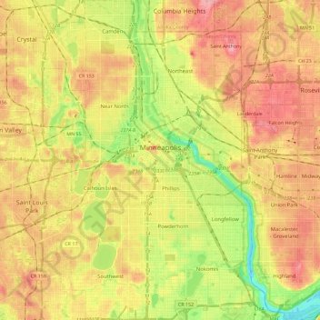
Name: Minneapolis topographic map, elevation, terrain.
Location: Minneapolis, Hennepin County, Minnesota, United States (44.89015 -93.32913 45.05125 -93.19386)
Average elevation: 886 ft
Minimum elevation: 692 ft
Maximum elevation: 1,043 ft
Hennepin County trails, hiking, mountain biking, running and outdoor activities
Make a donation
Gear up for your next adventure:
As an Amazon Associate, this site earns from qualifying purchases at no extra cost to you.
Other topographic maps
Click on a map to view its topography, its elevation and its terrain.
Elm Creek Park (Maple Grove Arboretum)
United States > Minnesota > Hennepin County > Maple Grove
Average elevation: 912 ft
Mississippi River
United States > Minnesota > Hennepin County > Minneapolis
The uppermost lock and dam on the Upper Mississippi River is the Upper St. Anthony Falls Lock and Dam in Minneapolis. Above the dam, the river's elevation is 799 feet (244 m). Below the dam, the river's elevation is 750 feet (230 m). This 49-foot (15 m) drop is the largest of all the Mississippi River locks…
Average elevation: 840 ft
Make a donation
Gear up for your next adventure:
As an Amazon Associate, this site earns from qualifying purchases at no extra cost to you.
Make a donation
Gear up for your next adventure:
As an Amazon Associate, this site earns from qualifying purchases at no extra cost to you.
Wood Lake Nature Center
United States > Minnesota > Hennepin County > Richfield
Average elevation: 853 ft
Eden Prairie
United States > Minnesota > Hennepin County > Eden Prairie > Eden Prairie
Average elevation: 876 ft
Make a donation
Gear up for your next adventure:
As an Amazon Associate, this site earns from qualifying purchases at no extra cost to you.