
Make a donation
Gear up for your next adventure:
As an Amazon Associate, this site earns from qualifying purchases at no extra cost to you.
Salem topographic map
Click on the map to display elevation.
Make a donation
Gear up for your next adventure:
As an Amazon Associate, this site earns from qualifying purchases at no extra cost to you.
Salem
Salem is situated in the heart of the Willamette Valley and features a varied topography shaped by its proximity to notable geological formations. The city itself is primarily located at an elevation of around 177 feet (54 meters), but it spans a range from approximately 120 to 800 feet (37 to 244 meters) above sea level. To the west of Salem lie the Eola Hills, which rise to about 1,000 feet (300 meters), while the Waldo Hills to the east reach approximately 700 feet (210 meters). The southern parts of the city, including areas with canyons, are particularly hilly, contributing to the landscape's diversity. Additionally, the volcanic Salem Hills can be found in the southern region, enhancing the area's rugged charm. On clear days, residents and visitors can enjoy views of the Cascade Range, including iconic peaks like Mount Hood and Mount Jefferson, providing a picturesque backdrop to the city.
Make a donation
Gear up for your next adventure:
As an Amazon Associate, this site earns from qualifying purchases at no extra cost to you.
About this map
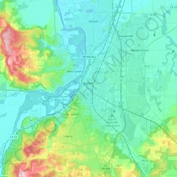
Name: Salem topographic map, elevation, terrain.
Location: Salem, Marion County, Oregon, United States (44.85125 -123.12296 45.01662 -122.93521)
Average elevation: 315 ft
Minimum elevation: 98 ft
Maximum elevation: 1,129 ft
Marion County trails, hiking, mountain biking, running and outdoor activities
Make a donation
Gear up for your next adventure:
As an Amazon Associate, this site earns from qualifying purchases at no extra cost to you.
Other topographic maps
Click on a map to view its topography, its elevation and its terrain.