
Livingston topographic map
Interactive map
Click on the map to display elevation.
About this map
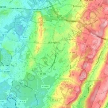
Name: Livingston topographic map, elevation, terrain.
Location: Livingston, Essex County, New Jersey, 07039, United States (40.75760 -74.37752 40.81842 -74.28059)
Average elevation: 341 ft
Minimum elevation: 154 ft
Maximum elevation: 620 ft
Essex County trails, hiking, mountain biking, running and outdoor activities
Other topographic maps
Click on a map to view its topography, its elevation and its terrain.
Saint Cloud
United States > New Jersey > Essex County > West Orange > Saint Cloud
Average elevation: 463 ft