
Make a donation
Gear up for your next adventure:
As an Amazon Associate, this site earns from qualifying purchases at no extra cost to you.
Palm Coast topographic map
Click on the map to display elevation.
Make a donation
Gear up for your next adventure:
As an Amazon Associate, this site earns from qualifying purchases at no extra cost to you.
Palm Coast
Palm Coast features a diverse and relatively flat topography, characterized by its coastal plain terrain, which gently slopes towards the Atlantic Ocean. The elevation typically ranges from about 10 to 30 feet above sea level, providing a subtle gradient that contributes to its scenic views. The area is interspersed with numerous freshwater canals, marshes, and ponds, enhancing its natural beauty and supporting a rich ecosystem. Dense clusters of subtropical vegetation, including palm trees and pines, add to the landscape, while nearby salt marshes and the sandy beaches provide unique coastal environments. Overall, Palm Coast's topography reflects a harmonious blend of inland wetlands and coastal features, making it a picturesque location for residents and visitors alike.
Make a donation
Gear up for your next adventure:
As an Amazon Associate, this site earns from qualifying purchases at no extra cost to you.
About this map
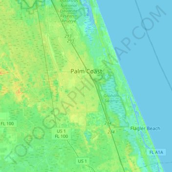
Name: Palm Coast topographic map, elevation, terrain.
Location: Palm Coast, Flagler County, Florida, United States (29.41410 -81.37164 29.65180 -81.14878)
Average elevation: 20 ft
Minimum elevation: -13 ft
Maximum elevation: 66 ft
Flagler County trails, hiking, mountain biking, running and outdoor activities
Make a donation
Gear up for your next adventure:
As an Amazon Associate, this site earns from qualifying purchases at no extra cost to you.
Other topographic maps
Click on a map to view its topography, its elevation and its terrain.
Make a donation
Gear up for your next adventure:
As an Amazon Associate, this site earns from qualifying purchases at no extra cost to you.