
Ely topographic map
Interactive map
Click on the map to display elevation.
Ely
Ely experiences a semi-arid climate (Köppen BSk), and extreme day-night temperature differences year-round. Ely's nighttime temperatures account for it being listed as one of the coldest places in the contiguous United States, with an average of 214.9 nights per year with a minimum temperature of 32 °F (0 °C) or less, 15.7 nights reaching 0 °F (−17.8 °C) or less, and 21.7 days when the high does not top freezing. On average, the first and last dates of freezing temperatures are September 8 and June 18, respectively, allowing a growing season of only 79 days. Frosts have occurred in every month, even July. The diurnal temperature range of Ely is so great due to its elevation, dry air, clear skies, and location in a valley, allowing for intense radiative cooling at sunset, even after hot summer days. The monthly mean temperature ranges from 26.7 °F (−2.9 °C) in January to 69.3 °F (20.7 °C) in July. High temperatures of 90 °F (32 °C) or higher occur on an average of 29.2 days annually, but, due to the elevation and aridity, the low very rarely manages to stay at or above 60 °F or 16 °C. Extreme temperatures ranged from 101 °F (38.3 °C) on July 18, 1998 down to −30 °F (−34.4 °C) on February 6, 1989.
About this map
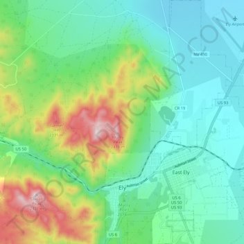
Name: Ely topographic map, elevation, terrain.
Location: Ely, White Pine County, Nevada, 89301, United States (39.22937 -114.90077 39.30950 -114.83319)
Average elevation: 6,709 ft
Minimum elevation: 6,220 ft
Maximum elevation: 7,979 ft
White Pine County trails, hiking, mountain biking, running and outdoor activities
Other topographic maps
Click on a map to view its topography, its elevation and its terrain.