
Fleming Island topographic map
Interactive map
Click on the map to display elevation.
About this map
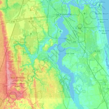
Name: Fleming Island topographic map, elevation, terrain.
Location: Fleming Island, Clay County, Florida, 32003, United States (29.77330 -82.03898 30.41330 -81.39898)
Average elevation: 62 ft
Minimum elevation: -10 ft
Maximum elevation: 259 ft
Clay County trails, hiking, mountain biking, running and outdoor activities
Other topographic maps
Click on a map to view its topography, its elevation and its terrain.