
Granada topographic map
Interactive map
Click on the map to display elevation.
Granada
Granada (Spanish: [ɡɾaˈnaða], locally [ɡɾaˈna]) is the capital city of the province of Granada, in the autonomous community of Andalusia, Spain. Granada is located at the foot of the Sierra Nevada mountains, at the confluence of four rivers, the Darro, the Genil, the Monachil and the Beiro. Ascribed to the Vega de Granada comarca, the city sits at an average elevation of 738 m (2,421 ft) above sea level, yet is only one hour by car from the Mediterranean coast, the Costa Tropical. Nearby is the Sierra Nevada Ski Station, where the FIS Alpine World Ski Championships 1996 were held.
About this map
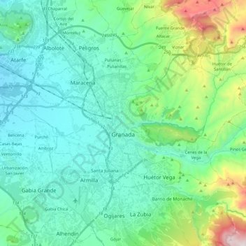
Name: Granada topographic map, elevation, terrain.
Average elevation: 2,720 ft
Minimum elevation: 1,893 ft
Maximum elevation: 5,997 ft
Other topographic maps
Click on a map to view its topography, its elevation and its terrain.
Alhambra
Spain > Andalusia > Partido Judicial de Granada > Granada
During the reign of the Nasrid Dynasty, the Alhambra was transformed into a palatine city, complete with an irrigation system composed of aqueducts and water channels that provided water for the complex and for other nearby countryside palaces such as the Generalife. Previously, the old fortresses on the hill…
Average elevation: 2,490 ft