
Atlasov Island topographic map
Interactive map
Click on the map to display elevation.
About this map
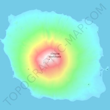
Name: Atlasov Island topographic map, elevation, terrain.
Average elevation: 1,093 ft
Minimum elevation: -16 ft
Maximum elevation: 7,530 ft
Other topographic maps
Click on a map to view its topography, its elevation and its terrain.
Alaid
Russia > Sakhalin Oblast > Severo-Kurilsky District
Alaid, Severo-Kurilsky District, Sakhalin Oblast, Far Eastern Federal District, Russia
Average elevation: 6,001 ft
Onekotan
Russia > Sakhalin Oblast > Severo-Kurilsky District
Onekotan, Severo-Kurilsky District, Sakhalin Oblast, Far Eastern Federal District, Russia
Average elevation: 217 ft