
Trenton topographic map
Interactive map
Click on the map to display elevation.
Trenton
According to the Köppen climate classification, Trenton lies in the transition from a humid subtropical (Cfa) to a cooler humid continental climate (Dfa), favoring the former, with four seasons of approximately equal length and precipitation fairly evenly distributed through the year. The Cfa climate is the result of adiabatic warming of the Appalachians, low altitude and proximity to the coast without being on the immediate edge for moderate temperatures.
About this map
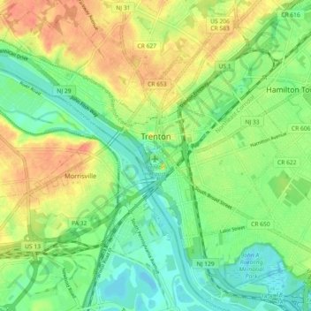
Name: Trenton topographic map, elevation, terrain.
Location: Trenton, Mercer County, New Jersey, United States (40.18383 -74.81958 40.24830 -74.72890)
Average elevation: 62 ft
Minimum elevation: -3 ft
Maximum elevation: 144 ft
Mercer County trails, hiking, mountain biking, running and outdoor activities
Other topographic maps
Click on a map to view its topography, its elevation and its terrain.
Hillside Terrace
United States > New Jersey > Mercer County > Robbinsville Township
Average elevation: 115 ft
Robbinsville
United States > New Jersey > Mercer County > Robbinsville Township
Average elevation: 105 ft
Coopers Corner
United States > New Jersey > Mercer County > Hopewell Township
Average elevation: 341 ft
Hamilton Square
United States > New Jersey > Mercer County > Hamilton Township
Average elevation: 95 ft