
Holland topographic map
Interactive map
Click on the map to display elevation.
About this map
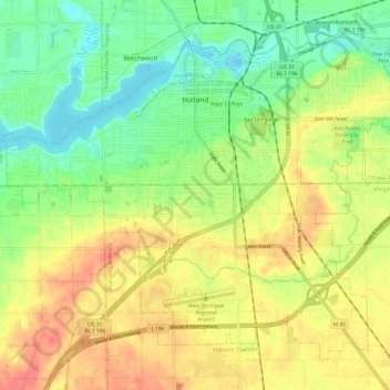
Name: Holland topographic map, elevation, terrain.
Location: Holland, Ottawa County, Michigan, 49423, United States (42.72934 -86.16699 42.80284 -86.04790)
Average elevation: 653 ft
Minimum elevation: 564 ft
Maximum elevation: 745 ft
Ottawa County trails, hiking, mountain biking, running and outdoor activities
Other topographic maps
Click on a map to view its topography, its elevation and its terrain.