
Lindside topographic map
Interactive map
Click on the map to display elevation.
About this map
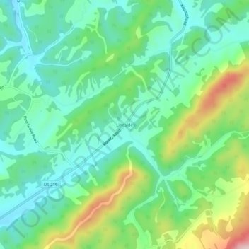
Name: Lindside topographic map, elevation, terrain.
Location: Lindside, Monroe County, West Virginia, United States (37.43373 -80.68979 37.47373 -80.64979)
Average elevation: 2,139 ft
Minimum elevation: 1,860 ft
Maximum elevation: 2,805 ft
Other topographic maps
Click on a map to view its topography, its elevation and its terrain.
Rich Mountain
United States > West Virginia > Monroe County
Rich Mountain, Monroe County, West Virginia, 24936, United States
Average elevation: 2,766 ft
Union
United States > West Virginia > Monroe County
Union, Monroe County, West Virginia, 28983, United States
Average elevation: 2,100 ft
Peterstown
United States > West Virginia > Monroe County
Peterstown, Monroe County, West Virginia, 24963, United States
Average elevation: 1,775 ft
Patton
United States > West Virginia > Monroe County
Patton, Monroe County, West Virginia, United States
Average elevation: 2,070 ft