Geolocate

Union topographic map

Click on the map to display elevation.

About this map

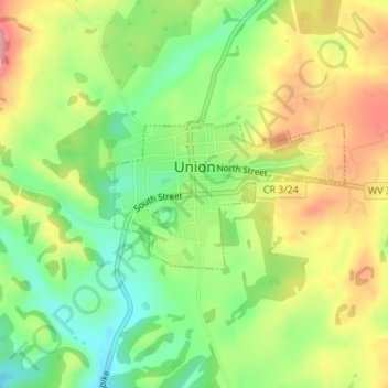
Name: Union topographic map, elevation, terrain.

Location: Union, Monroe County, West Virginia, 28983, United States (37.58446 -80.55047 37.59487 -80.53020)

Average elevation: 2,100 ft

Minimum elevation: 1,923 ft

Maximum elevation: 2,306 ft

Monroe County trails, hiking, mountain biking, running and outdoor activities

Other topographic maps

Click on a map to view its topography, its elevation and its terrain.

Hollywood

United States > West Virginia > Monroe County

Average elevation: 2,382 ft

Gap Mills

United States > West Virginia > Monroe County

Average elevation: 2,510 ft

Pedro

United States > West Virginia > Monroe County

Average elevation: 2,651 ft

Rock Camp

United States > West Virginia > Monroe County

Average elevation: 2,093 ft

Gear up for your next adventure:

🥾Hiking Shoes - Durable and comfortable shoes for trail hiking
🛠️Outdoor Gear Repair Kit - Essential tools to fix gear on the trail
🧣Hiking Neck Gaiter - Multi‑use neck protection for outdoor weather
🔌Solar Panel Charger - Charge gear sustainably outdoors
📚Navigation Handbooks - Master the art of reading topographic maps and using a compass

As an Amazon Associate, this site earns from qualifying purchases at no extra cost to you.