
Mount Marcy topographic map
Interactive map
Click on the map to display elevation.
Mount Marcy
Mount Marcy (Mohawk: Tewawe’éstha) is the highest point in New York, with an elevation of 5,343.1 feet (1,628.6 m). It is located in the Town of Keene in Essex County. The mountain is in the heart of the Adirondack High Peaks region of the High Peaks Wilderness Area. Its stature and expansive views make it a popular destination for hikers, who crowd its summit in the summer months.
About this map
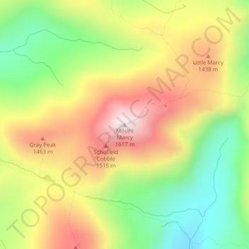
Name: Mount Marcy topographic map, elevation, terrain.
Average elevation: 4,229 ft
Minimum elevation: 3,232 ft
Maximum elevation: 5,299 ft
Essex County trails, hiking, mountain biking, running and outdoor activities