
LaBranche topographic map
Interactive map
Click on the map to display elevation.
About this map
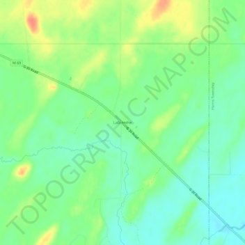
Name: LaBranche topographic map, elevation, terrain.
Average elevation: 948 ft
Minimum elevation: 886 ft
Maximum elevation: 1,047 ft
Other topographic maps
Click on a map to view its topography, its elevation and its terrain.
Menominee
United States > Michigan > Menominee County
Menominee, Menominee County, Michigan, United States
Average elevation: 594 ft
Wallace
United States > Michigan > Menominee County
Wallace, Mellen Township, Menominee County, Michigan, 49893, United States
Average elevation: 686 ft
Cedar River
United States > Michigan > Menominee County > Cedar River
Cedar River, Cedarville Township, Menominee County, Michigan, United States
Average elevation: 584 ft