
Thank you for supporting this site ❤️
Make a donation
Make a donation
Gear up for your next adventure:
As an Amazon Associate, this site earns from qualifying purchases at no extra cost to you.
Nebraska topographic map
Click on the map to display elevation.
Thank you for supporting this site ❤️
Make a donation
Make a donation
Gear up for your next adventure:
As an Amazon Associate, this site earns from qualifying purchases at no extra cost to you.
About this map
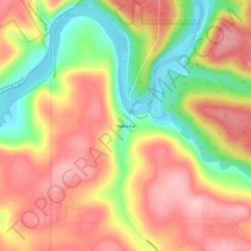
Name: Nebraska topographic map, elevation, terrain.
Location: Nebraska, Forest County, Pennsylvania, USA (41.44923 -79.40338 41.48923 -79.36338)
Average elevation: 1,421 ft
Minimum elevation: 1,086 ft
Maximum elevation: 1,677 ft
Thank you for supporting this site ❤️
Make a donation
Make a donation
Gear up for your next adventure:
As an Amazon Associate, this site earns from qualifying purchases at no extra cost to you.